Saturday 7 April 2018

Fitzroy Island to Orpheus Island via Hinchinbrook Channel

Having spent a glorious afternoon at Fitzroy Island,the inclement weather shifted from Cairns  to settle over us during the early hours of the morning.

Awaking to drizzle and slightly more than that, as we got underway, we set sail for Mourilyan Harbour.  The wind being ok for a while then dying to nothing and then as the rain decreased to showers and finally disappeared altogether, a great breeze set in.
Never thought I would be sailing into here,when I left in 2005


o yes beautiful Mourilyan Harbour
Sailing into Mourilyan was brilliant fun.Inside the two headlands there is a wonderfully protected harbour and we anchored just clear of the swing basin on the shoaling mud bottom.


Those tugs look a little more powerful than the ones that used to be here .


Mourilyan to Cape Hinchinbrook

Again the next morning dawned drizzly, but with wind from the right direction. Approaching Dunk Island, the wind was in the right quarter to set the MPS, ahead of us the black wall of an approaching front precluded that idea, and  it  soon bucketed down again, before clearing into a rather stunning , but ultimately windless afternoon, which left us motoring into the Hinchinbrook Channel.

At the top of the Hinchinbrook Channel.

I suspect that it's not only a soft drink in that glass.
Lookout duties? ,Hmmm?

Awakening to more low cloud, which actually made Hinchinbrook look stunningly akin to somewhere in the Scottish Highlands , as its towering height disappeared into the clouds, as did the Cardwell Range on the mainland. We motored through the Hinchinbrook Channel, on a rising  tide so no chance to see the 'mud lizards' on the banks at low tide.Mind you it wasn't overly sunny ,so even at low water it is unlikely there would ave been many crocodiles sunning themselves.
I must return to this neck of the woods, and explore.

pot of gold?

a different view of Hinchinbrook Island

rainbow from port to starboard


Beautiful

Passage through the Hinchinbrook Channel


Scale: Jo at 1m distance ,Fw Buoy at 100m perhaps- it's still a toy FW By!
We motored out past the Lucinda Bulk Sugar wharf, which at close to 6km in length is the longest in the Southern Hemisphere, and which I have driven many times to and from the vessels I piloted at Lucinda.We cleared the Lucinda  Fairway Buoy, goodness knows how small it must look from a ship these days, as the current buoy  looks pretty small from a yacht at close range, and had a really great sail across to Pioneer Bay at Orpheus Island


Thursday 5 April 2018

Fitzroy Island

After taking up our mooring there was only one thing to do, and that was not to trek to Fitzroy Island Lighthouse.
 The lighthouse here being my least favourite of the Queensland coast, that we serviced, during my time on the lighthouse tender MV Cape Moreton.

Photo from internet 
photo from internet as mine not with me 
It has always reminded me for some reason of a  public urinal.Goodness knows why, as public urinals are not in fact, something I am familiar with, other than the knowledge they exist. I think it is the external tiles, that didn't do it for me. I realise it is supremely functional, having obviously safely lit the way through Grafton Passage for ships, for  many many years, but aesthetically, it has not one iota of the romance of the lights of Low Isles, Cape Bowling Green , Dent Island, Cape Capricorn, Bustard Head, Cape Moreton, Sandy Cape, or even Australia's probably most visited light at Cape Byron. They are all , or at least were, both functional and beautifully romantic looking  lights, when I saw them back in '79.

So instead of visiting my least favourite light, it was into the water to inspect once again, what was going on down there.
There was substantially less weedy growth than when we  arrived in Cairns 3 weeks ago, so something had seen it off , whilst in the marina. My main focus, other than giving the hull growth a squizz , was to check the rate of consumption of the annodes on the sail drives and props.

I know if you have read much of this blog , it must appear I'm obsessed by what lies beneath. Mea culpa! It's what you can't see that is going to cause the most problems. Leaks, wear and tear, aloft and below, that is what is going to surprise you one day, and odds are, it wont be a nice surprise.

The night revealed that we are going to have to refine our buoy mooring technique. As we swung on the mooring during the night, the mooring buoy kept attacking us. To date this hasn't occurred as when we have picked up other moorings it has been in a current stream, or breeze which was sufficient enough for us to ride at a suitable distance and not override the buoy. Back to the drawing board, on that one.
 They are not insubstantial and yes they do bang on the hull, being made of hard plastic. The tail with the eye in it that comes aboard is a couple of metres long but still we over rode it.

We wont succumb to scurvy on our way south


Jo arrived and we had another day or two in Cairns, as she too had lived in Cairns for some time.In fact there were still more people around that she knew and wanted to catch up with than for me.

When we did in fact depart, it was with a supply of wonderful fresh greens and herbs , papayas ,cucumbers and beetroot, which I forgot to photograph ,from David's garden up on the Tablelands - ...as well as mangos and limes and lets not forget the bottle of Botanic Australis Gin, from Carrie.
The gin  is distilled on the Tablelands, and  I look forward  to sampling it and comparing to my current favourite, Bombay Sapphire.
I shall report back later on that.

There will be no chance of scurvy on K'Gari,  this leg of the voyage !


It is distilled with 14 native botanics according to the label. Lemon myrtle, finger lime, lemon scented gum, lilypilly, wattle seed and pepperberry, to name a few.


From this ...

It was overcast and drizzling when we left, sailing out of the inlet on the last of the flood tide, destination Fitzroy island .it was only 17 miles to Fitzroy and we managed a sail for an hour or two, but then the wind died, so we motored into the bay at Fitzroy and picked up one of the moorings.


.....to this in 17 miles and 4 hours - it's called localised weather.

Cairns


We arrived in Cairns to berth  at Marlin Marina , having motored the last 38 miles , from Low Islet due to a complete lack of wind.

There was much to do.
Some 10 miles out,  I had been granted permission by Border Force to complete my importation in Cairns.It had become obvious we were never going to make it to Bundaberg (the stipulated port for clearance, in the document granted in Darwin), within the time frame.
Peter was going home and my next anticipated crew had advised me ,when we were  in Cooktown, that he was very likely  going to have to withdraw for family reasons, so I was going to be in Cairns for a couple of weeks.

The completion of the importation took eight days,and then I was no longer under Border Force control- free to go, just awaiting the arrival of Jo, who was now available to the leg south, as Chris would finish school on the 17th November, meaning she could come with me. Chris didn't want to.

In the meantime, although  Cairns had been home for me for 12 years , I was now seeing it from a totally different perspective. The marina is great , minutes easy,(flat) walk from the town, restaurants,cafes, ranging from takeaway to fivestar. Supermarkets within walking distance, one of which will deliver right to the marina. A little further afield, when on shanks' pony, there are all sorts of wonderful purveyors of useful marine things.Several chandleries, rubber matting stores, hardware emporia, and the very wonderful guys at McLeod Engineering- whoops, more deservedly free advertising!

I needed to do  some more regular maintenance tasks, but was a tad hesitant, so I contacted them and they obligingly sent the very helpful and patient Zane down to show me how to do the tasks that I needed to complete, on one engine, and then in my own time I took care of the same  basic tasks on the other engine, knowing that I could call them for assistance if I got it wrong or had any more questions. So some  more knowledge stowed away in the memory bank- I hope! Zane also inspected and took away the mixer elbows from both engines to clean/ or replace.A couple of days later two new elbows were back in position, the engines were run up and tested. That just leaves the sail drive oil and anodes to be done when out of the water, which I'm anticipating now will be Mackay.

Minor other maintenance was left to fiddle about with, but nothing urgent, so that left time to enjoy being just  minutes walk from the Esplanade, which in Cairns, comes complete with free pool, beautiful surrounds, free bbq facilities, free wifi in the vicinity of the pool, no wonder tourists and backpackers young and old, love Cairns.For the Europeans, the weather itself would be glorious, let alone the wonderful facilities.
Towards the Esplanade

path to town
Also there was time to catch up with three of the four people I still knew of living  in Cairns, which was lovely.The fourth unfortunately being in Brisbane at the time. One of the things that I have been definitely blessed with in this life, is that those I count as friends, are the people with whom I need not see for years and yet, when we catch up, it is as though not much has intervened, despite the passage of more than a decade in time.
Part of the social whirl of being on a yacht in a marina , is meeting  new and  catching up randomly, with old  friends on boats. Cairns was no exception. In the two and a bit years I have been playing on K'Gari in SE Asia ,I can't imagine how many people I have met. Here in Cairns it turns out, were two of them. One I had met in Langkawi- another Seawind owner,now berthed two pens away and the other couple, in Phuket, whilst I was out of the water doing my slipping.Jeff and Marin where finishing off a major refit of their catamaran in the same yard, and now they had arrived Cairns on their way to the South Pacific. 


Wednesday 4 April 2018

Low Isle


Low Isle is one of my all time favourite stops. I can't really say anchorage as there are buoys to moor on.


It is picturesqe in the extreme. A jewel of a coral cay, capped by the magnificent light house with its white superstructure and red domed roof above the all important light.

The light is situated on the sandy cay on the NW side of the reef. The larger but lower cay on the eastern side of the reef, which is lightly wooded is home to hundreds of nesting terns.

The waters come complete with very friendly bat fish, who arrive, I hope not looking for food, as soon as they realise that a newbie has arrived on the mooring, as do quickly, the black tip reef sharks.
ok the boardies have seen better days, but the focus is really on the lighthouse

The island is part of the National Park system and is the closest to Port Douglas.
The light like all lighthouses in Australia now , is unmanned, but the lighthouse keepers houses are now used for the NP ranger who lives on the island.
Low Isles was the first light to be converted to solar power operations, from memory, in the early 1990s, prior to  the station becoming unmanned in 1994.
Bat fish and trevally

Bat fish and ramoras- remember one of these little suckers rated a mention once before.
Four foot blacktip and friendly ramora 


Cooktown

I have cruising friends who have been stuck in Cooktown for weeks, waiting for a break in the SE'ly wind.
Cooktown from our "deep water " anchorage.
The last time I was in Cooktown was probably 12 years ago. Between '94 and 2005, I estimate I visited Cooktown, by road,still with long dirt sections then, half a dozen times, generally for pleasure, but also once or twice for work. Then I could barely notice any change , other than the botanical gardens which had been total overgrown when I first visited as a child in 1975, had been uncovered and revived.

Now in 2017, I was surprised to see the amount of revitalisation of Cooktown that has taken place.It's great, really well done,thanks to the driving force behind it, whoever you are. Cook Shire Council perhaps?

I had been impressed with the botanic gardens , years ago, who would have thought somewhere so far from anywhere would have had such a thing.

Incredibly appropriate really  as Capt Cook spent many weeks on the bank of the Endeavour River repairing his 'slightly' damaged ship. Joseph Banks and Daniel Solander, who were also aboard and were  the botanists who took so many samples of the strange , not seen in Europe, flora and fauna, must have had a wonderful time here.As the Cooktown orchid is the  floral emblem of Queensland , what better place for there to be a Botanic Garden of such historic value.

I have  on several previous visits been to  the James Cook Museum, located in the old convent. The name may be slightly misleading,it's not just about Capt Cook, there is much of the history of the gold rush on the Palmer River found here as well as the history of Cooktown itself.
In its hey day during the goldrush in the 1870's ,it was a thriving port, bringing the hopeful diggers and much needed supplies.Pubs abounded.

Today there are major plans for the development of the foreshore and esplanade on display, something I look forward to seeing when next I visit Cooktown.

The Post Office


A wander up   Webber Esplanade and into Charlotte St, takes you from the wharf,  past the spot where the Endeavour was careened and repaired, a statue of Capt Cook, a monument to Capt Cook, the RSL,which is in a building that was originally the shire hall , the Post Office,
then a monument  to Mrs Watson , of beche de mer vat drifting fame, the other side of the street has a couple of the old banks, the courthouse (rebuilt) but on original site and although  I don't usually do advertising, the Sovereign Hotel is going to get a mention here. We had the best eye fillet steaks for tea. Tender,cooked perfectly to order and just the right size. I would go back to Cooktown again just for the steak!


Departing early in the morning

Cape Flattery


From Lizard Island it was a motor sail to Cooktown, passing enroute, Cape Flattery the silica sand export facility. Good to see the wharf still in tact. I haven't been to Flattery since leaving Cairns in 2005. There was one ship waiting at anchor as we passed by.


I guess after 14 years not many of the 'faces' who were there when I went to Flattery, would still be there.Times change , people move on. The 182 pilotages I executed at Cape Flattery are still to this day, the most exhilarating and satisfying of any of the several thousand I have done.
 No tugs, just wind and current ,the ships anchor ,the ships engine, a single propeller, my brain and the foresight of  Capt Paul Matthews, whose conceptual idea came to fruition in 1987 and is still functioning as envisaged.
Prior to the construction of the wharf, ships would anchor in the bay on the northern side of Cape Flattery and load the silica sand by barge.This meant having to heave anchor and shift to deeper and deeper anchorages as the loading progressed and the ships draft increased. The construction of the wharf on the southern ( weatherside) of the Cape, reduced the loading time by many days as well as increasing the shipment size and consequently the size of the ship.
Another successful berthing at Cape Flattery in progress (1997). A wharf strategically positioned
across the prevailing wind and current to allow berthing ships up to 190m without tugs.
See that sand in the background- that is the cargo!
photo courtesy of Capt John Foley
A trip down memory lane for both of us, as my current trusty crew Peter, was also instrumental in the beginnings of this wharf, having been there from the conception to executing some of the first pilotages at this facility. Peter still vividly remembers the day when he and Paul took a ship from the northern anchorage around to the vicinity of where the wharf now stands and convinced the ships Master to allow them to get in close enough to the land, to trial an anchor manoeuvre and test the strength and direction of the current . These days such research is carried out on a ship simulator. It was a brave ships Master who allowed them to do this, a glance at the chart excerpt shows the depths decrease rapidly from 14m to 5m and less, just the other side of where the leads now exist, and this is a lee shore when the weather conditions are actually  perfect berthing.


This place is remote. It is a 50 minute  flight from Cairns in a twin Cessna landing on a dirt strip, 120nm from Cairns by sea, and 440 odd km (7-8 hrs driving) by road in a  4WD from Cairns.
It  looks beautiful, the water looks inviting, but when I was there, the wharf supervisor had a laminated A4 set of photos of some of the wildlife that shares the facility. A croc sunning its self under the conveyor belt, sharks caught by the employees on their days off, a python hanging the full length of a toilet cubicle, and my favourite,other than the croc, was the shot of a python with a half swallowed baby wallaby in its jaws.
 I would tell the Captain swimming not allowed, and Will or Wayne,  the supervisors, would quite often have the photos with them when they arrived after the berthing, just to reinforce the concept of the crew staying on board.

So the morning was well and truly taken care of, coffee, kit kats as we continued south towards Cooktown,and  reminiscing about the buzz (of the occasionally heart in mouth type) that berthing a ship at Cape Flattery can give, which honestly, only those who have done it, can appreciate.
this photo is taken from a CF web page as I haven't got any of mine  with me at time of writing 


A steady 5.2 kts, using both a motor and then  eventually about mid morning under sail, had us arriving in Cooktown at 1530.

We anchored in a massively deep 2.3m of water  on sand and went ashore for the evening, after ensuring we were snug.

Monday 2 April 2018

Lizard Island.

We arrived at the anchorage in the bay on the NW side of Lizard Island at 0745.
The chart shows a brilliantly straight run across from the Howick Group - because, we motored.The wind just died completely at 0200. As we had by then passed the Howick Group and the possible anchorage at Coquet Island,it was just as  easy to go on, to anchor in daylight at Lizard, as it was to  return, to the Howick group and try anchoring in an unknown location in the dark.

We needed to stop to sleep as it had  turned out to be a 48hour  run from Portland Roads , as we had tried to make best use of  the changing winds. It is so much easier to sleep when anchored securely in a bay out of the tide/current stream and  without the constant nagging thought of dragging the anchor and  being awoken  by crunching/grinding noises.

Lizard Island fitted the bill perfectly. Sandy bottom, 3.5m depth,clear water.What could be better?

The anchorage , for us, was pretty crowded. A mixed dozen or so, of sailing yachts and engine powered vessels.

We anchored, rigged the shade cloths, as there was no sign of any sort of breeze developing and then slept.


After sufficient snoozing, it was time to use the opportunity to check under the hulls again. I haven't been in the water to check since Kupang. Darwin was out due to the definately not clear water and  crocs, Seisia, crocs and current and probably sharks .The same for Savage River and Portland Roads. SE Asia did definitely have some obvious advantages!

First though, we went for a snorkel (swimming or drifting along with the dinghy in tow) over the nearest coral. Not the worlds most stunning coral, but a high bench mark has been set already on our travels. Then we set off to check out the "visitor mooring" as denoted on the chart, which is around in a bay on the northern end of the island. Here on the mooring, but in a depth of  water, the clarity of which was so good, the coral appeared very close, we met a couple heading north on a Seawind 1160.
Returning to K'Gari it was time to check out what she was like underneath. Pretty damn good actually. The worst I could see was a green slime above the water line which had first appeared in Darwin and hadn't just washed away as we sailed south as I had assumed it would.It was now fairly solidly stuck to the gelcoat, but didn't appear to be getting worse. All the through hull inlets were in good shape, clear of growth.The ground plate was a bit of an oyster patch again, but then as the HF was in Darwin being repaired, it didn't matter that much. The antifoul was looking great and less than a dozen barnacles had tried to tag along for the ride.
Back on board and hanging up the de rigeur stinger suit to dry, what did my startled eyes alight upon in the water , a three foot black tip reefy (shark) meandering by, on this beautiful afternoon. Just as well we had already been in the water.

Time being of the essence just at the moment, we decided to not do a Capt Cook, and ascend the peak , as that would require both time tomorrow morning and effort, and we have perfectly adequate charts showing us the way to go home.Perhaps another time, the middle of winter seems like a much better idea to me.

We did go ashore in the afternoon.Obviously not to the resort, which does not welcome yachties, but a wander along the beach and as far as Mrs Watsons cottage- well, what they think might be a corner wall of it!

.Photo ©  Queensland Museum 2010
Mrs Watson for the un-initiated ,being the wife of a beche-de-mer fisherman who in 1881, took to a beche-de-mer cooking vat   with her baby and Chinese servant , to escape attack from some incensed locals. They drifted to the Howick Group,making landfall but finding no source of water and perishing from dehydration. Frankly my life raft has bigger dimensions than the vat pictured here.

If I thought the anchorage was busy when we arrived, it certainly filled up towards sunset. close to two dozen game fishing boats and a couple of  larger cruisers arrived for the night.


Looking out from the beach at sunset.
 If you click on this photo you can enlarge it and actually see the boats in the anchorage

Peak hour in the Reef

Peak hour for us occurred the next morning as we were approaching Corbett Reef, some 70nm later.
As we approached the 2.5nm gap between Corbett and Rodda Reefs, with the wind having how veered towards the ESE again, it was of course  Mr Murphy at play, that had us meeting in that area with three ships, all doing considerably more speed than us,as we were now having to beat (tack) our way through the gap.

First to deal with, was the RTM Twarra  northbound , I gave it a red hot try, but decided to live to fight another day and threw another tack in, to pass around its stern.Then in succession it was the Tenjin Maru and the BBC Asia, southbound . Having piloted the first two and several of the sisterships of the BBC Asia, I know what it's like when yachts want to play chicken with you . So to keep everyones blood pressure in check, all I needed to remember was, I was now the smallest of them all. No point in it ending in tears!


Continuing on we thought about stopping for a snooze in Princess Charlotte Bay ,as the wind was forcing us progressively closer to the Flinders Group. Then true to form the wind backed again for the afternoon ,which made the choice somewhat easier.

We tacked out of Princess Charlotte Bay and  onwards towards  either the Howick Group or perhaps Lizard Island.

Never did get that prawn lunch at Portland Roads ,because.......

The weather didn't look too bad the next morning, hiding as we were in a protected bay. Seriously though, looking out to sea from our anchorage, the sea state had moderated a great deal, and the lure of an internet signal enticed us into to being on our way.

What did we have to loose, by just poking our nose out around the corner and seeing what it was like? Planned destination for the day, a mere 11nm away, to the shelter of Lloyd Island off Quintell Beach and the possibility of a signal for the internet!

Away we went, conservatively reefed down for what we expected would be stronger wind, once we rounded and passed Restoration Rock.
Restoration Rock seen  to port .Restoration Island  is to starboard
Why Restoration Rock? Time for another William Bligh fact, as we are apparently following in reverse,  his route to Kupang , but soon our courses will finally diverge.
 Bligh, having been floating around in somewhat less comfort than ourselves, enroute from Tahiti,to somewhere hospitable,happened upon the aptly named Great Barrier Reef. Unlike one of  his predecessors, he managed to nail an entrance, using his trusty sextant , chronometer and what chart there was- although how that works without a chart is still a mystery to me , as the trusty chronometer and sextant would only be  a record of where he had been- none the less , he made it through, so well done Lieutenant Bligh.

History (and  I suppose Bligh's journal) reveal that they landed some 25nm NW from this entrance at what we now know as  Restoration Island ,so named  for  the dual  facts that they landed on the day that celebrated the restoration of Charles the second to the throne and secondly as  they apparently felt mightly restored,having  dined on oysters and fruit and water they found there.

We passed safely between the island and the rock, and didn't stop to dine on either oysters or fruit. Coffee and a kit kat for us instead .

The weather moderated throughout the morning, so we reassessed and decided to make for Night Island, a further 25nm south from Lloyd Island. Allegedly an internet signal was found in this anchorage as well.

We had jagged an updated weather report as we passed through the zone off  Restoration Island, so were happy that the weather was in fact easing according to the Met Bureau prognosis as well. 

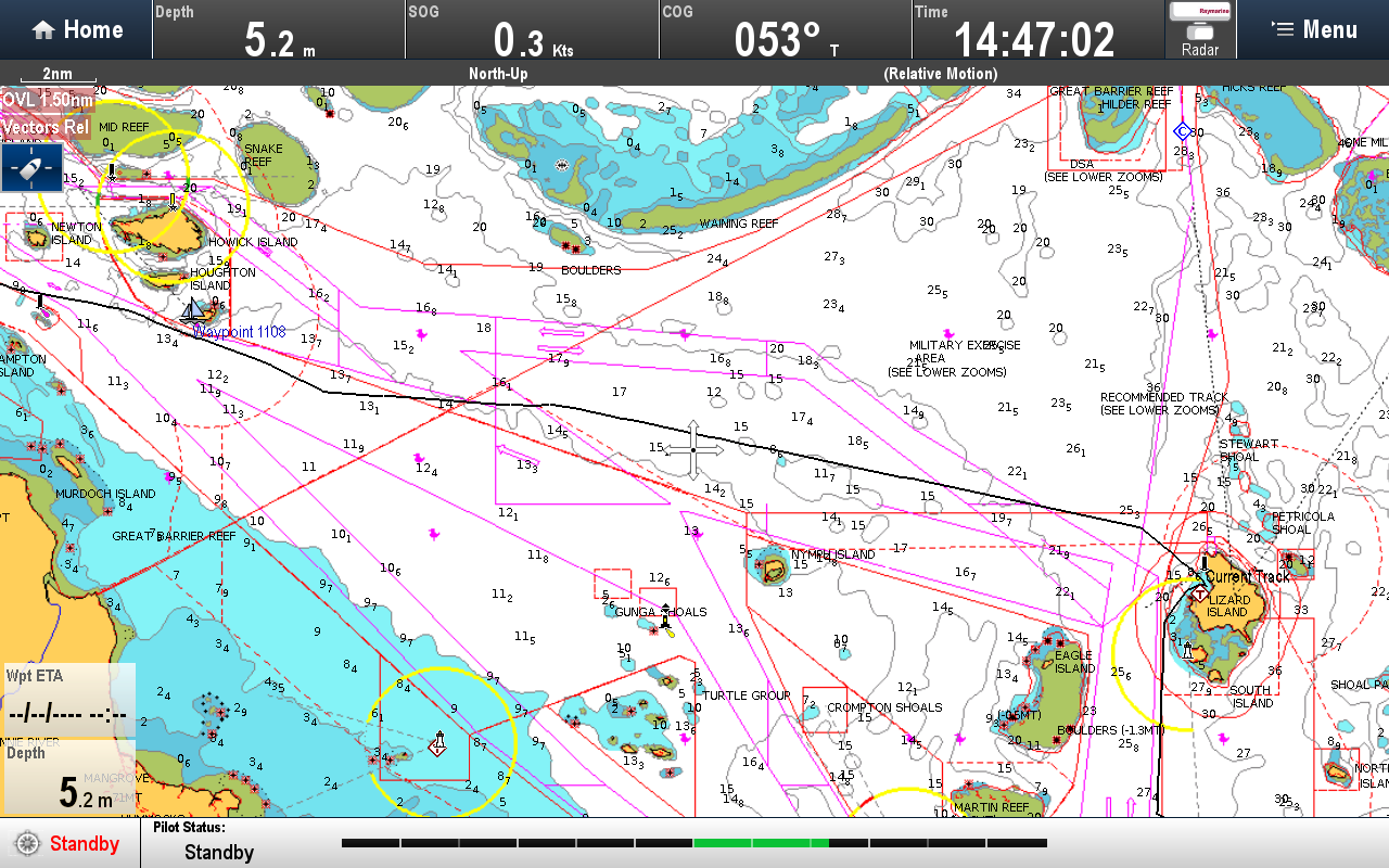
The last time I passed through the Reef in my professional life was, I calculated, 1981. I was certainly aware that many, many more navigation aids-(lights) had been added to the Reef over the years, but was oblivious to the fact that a new route had opened in 2004. The new route which is  inside the outer reef edge, is basically a straight line run, which means that no longer does all the traffic have to navigate the 120nm Inner route down through Princess Charlotte Bay,which for us, would culminate with a 25nm leg  to the East at the end, to round Cape Melville, which with the prevailing wind would have rated highly  on the scale of nightmarish to tedious.
By using LADS Passage -so named after the "Laser Airborne Depth Sounder  flight, which conducted the majority of the hydrographic survey work for identifying the new route" **  we would be able to both save 25nm and  take advantage of the wind which was now  forecast to back from the ESE to NE- perfect!

So plan change number three and we took advantage of what both mother nature was promising and the splendid work of the Australian  hydrogphers.

One long tack of 11.5nm, took us out of Lloyd Bay, to a position we could commence our run south. The wind didn't quite back far enough so another tack was required which  took us towards the reef again , just south of Bligh's entrance and then we were away.
Using the magnificent depth information available on the chart, we stayed to the East of the official outer track and had a brilliant run through the night, in the  little over a quarter  waxing moonlight and a E- NE'ly breeze Oh yes, this is what it's all about!

track out of Lloyd Bay and run down inside the outer edge of the Reef.
NB Old route (still an option) is seen  closer to the coast

Same same, but different scale 


** information obtained  from LADS Passage and Fairway Channel article 01.01.2008