 |
| Approaching the Eastern Anchorage Singapore |
Singapore has a traffic scheme for ships, just like roads. The ships transiting through the Straits in the Singaporian waters, are obliged to check in at various points, by VHF Radio and obey the rules.
The Straits are shared with Indonesia to the South of Singapore Island and with Malaysia to the West and North of Singapore Island.
Ships, there are hundreds of them, an endless stream of them 24/7!
Through the instigation and use of the traffic separation scheme, ships transit through in an orderly and safe procession, either west to east or east to west, cutting out of the scheme as they approach their various destinations. The container ships can do up to 25 kts. K'Gari can't!
The ships are supposed to move through at roughly ten minute intervals, I have been told, which of course doesn't really work when a 20 knot ship is overtaking a 10 knot ship, but as a general rule of thumb, its close enough.

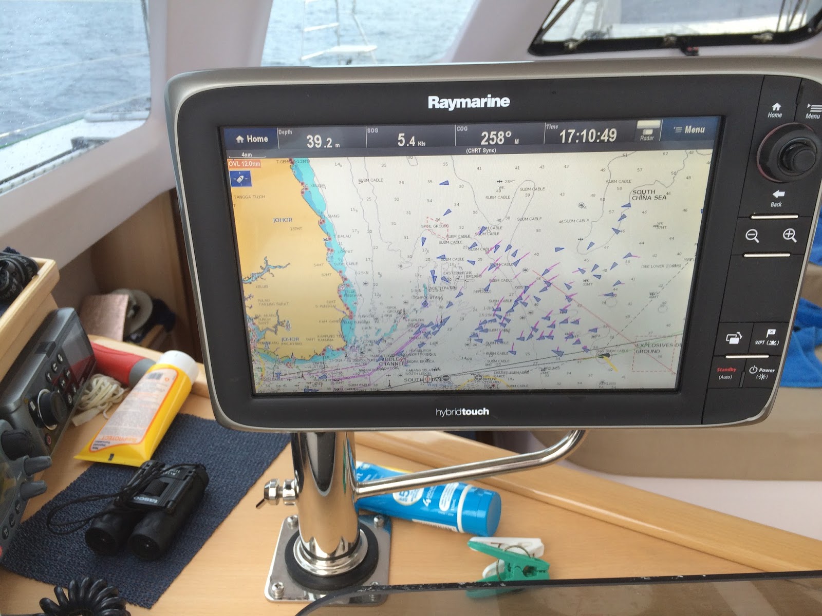
Snapshot going through the Singapore Straits
Blue triangles are ships in the traffic scheme.
Magenta sweeps around the ships is my radar ,picking them up.
The magenta thick line to the right of the photo is the imaginary, but charted, traffic separation zone- unlike roads, the ocean has no lines on it!
K'Gari is the black vessel to the south (or bottom) of the picture.
yellow land to top is Singapore, to the bottom it is Indonesia.
We were sticking to the Indonesian side, letting the big boys play by themselves, at speed, in the traffic scheme.
Something this snapshot does not show, is that although it appears to be daylight in the photo, it was in fact black, apart from the hundreds of lights from ships navigation lights, fishing boats, fishing nets, and shore lights!
So what have I gleaned prior to entering the Singapore Straits in an 8 tonne yacht moving at 6kts, as opposed to something, say , a 100000 tonnes moving at speed.
Firstly the current is going to have a huge effect. Heading into a 3 kt current effectively halves our speed, where as a ship doing 15 kts merely does 12kts instead. So try to time arrival to carry the tide as far as possible in the right direction. As the distance we were going to need to cover was about 50 odd miles, we were going to be transiting over a change of current direction, no matter what time we entered. The only way to avoid that, was stop and anchor and wait for the tide to change. Not a preferred option really, may as well just keep beetling along.
Secondly although K'Gari looks quite big when you are standing on her, she is really just a speck, (beautiful, but still a speck) when being looked down upon from the navigating bridge which is 30m or more , above the water line, of a 100000 T container ship doing 18- 25 kts
I already know the rough distance ahead of them, that they cant see you, if you are on the waterline , 300-400m roughly.
Thirdly, try to avoid the transit when visibility is reduced.Smoke ,rain squalls etc.I wonder if nighttime counts ? Well it doesn't come highly recommended in available yachtie literature, but I'm quite happy with my background, that it wont cause too many issues.
Backup contingency plan is stop the transit over near Nongsa Point Marina ( Indonesian waters) and wait till daylight.
So away we go.... Step one, drop and stow the sails, this is going to be a night of motoring only.
Did I mention the fishing nets?
As we were navigating up the Indonesian coast , well to the south of the traffic schemes, we did find the odd ( well actually many, many, many) nets, set by the Indonesian fishermen.
The first of these we encountered just on dusk. They are simply, a couple of 100m long and deployed from very small,very fast boats.They are marked at either end with a stick and a strobe light flashing away. The rest of the netline ,that we could see, is marked by floats or old drink bottles or polystyrene. The actual net hopefully sits about 2-3m below the surface.
Somewhere in attendance, nearby are the fishermen. What we found was, that suddenly a torch beam would flash at us from out of the darkness, if the fishermen thought we were getting to close or hadn't seen their net. They are incredibly hard to either see or judge the distance to, in the dark.Faint strobes flashing against the background of all the other lights.
All the way across from KK, the three of us had been keeping loosely timed navigating watches of about 4 hours on and eight off. Always someone was awake and on watch. Tonight there was no way I was going to sleep and to make it easier, spotting the nets etc, we decide to have two up and about, for the transit.
By about 2300, I was beginning to flag, so had a wee camp on the saloon lounge, leaving Peter on watch , with me just a couple of feet away inside, with my eyes shut. Possibly even asleep!
Just after midnight, I awoke, hearing my name being shouted and our torch, (nicknamed the lighthouse) waving about somewhat wildly.
We had unexpected visitors sitting right beside us, on the port quarter, definitely keeping pace with us, at our 6 knots.
Four gentlemen, outfitted in black , one complete with balaclava,sitting beside us in a black unlit ( no navigation lights )RIB dinghy.
They asked Peter to "please turn off the torch, its blinding".
That's the idea, when you sneak up astern of us at 30 knots!
Indonesian Polisi! ( not overly decorated with identifying insignia). Quick chat, about what we were doing, where we going and they bade us a "be careful, safe journey" and disappeared as fast as they had arrived into the night. My heart rate subsided about an hour later- not of course helped by the cup of coffee that was immediately consumed upon their departure.
Guns or no guns? I don't know, I cant remember seeing any.The incident is keenly etched in my mind, but that detail is beyond me.
I'm reliable informed, having just asked, that they did have guns, in holsters.
Wide awake now , can't imagine why, and on we go. Then it started to rain, light at first followed by the usual equatorial deluge. That was fun.Just a couple of tug and tows to negotiate our way around, during the rain.
At 0530/26th , we did the obligatory right angle alteration of course, to get across both lanes of the traffic scheme.The total distance width of the lanes , is only 1.5nm (2778m). The nearest lane to us was the east going lane,no problems there. Then we were momentarily in the miniscule "invisible" separation segment,(the thick magenta line similar to the one in the photo above) before dealing with the stream of ships moving to the west. At the speed we doing against the current it was going to take about 7.5 mins to get across.Lucky the ships are allegedly 10mins apart! It's still dark at this time of the morning and it had been a long night.
Time for "Mach 1". Both engines on, both just about flat chat.
OK, here comes the gap I'm looking for. A container ship doing 15 kts- that will do. Initially by steering at 90 degrees to the container ships bow , means we will never hit it- unless she stops, and that isn't likely.
So with everything we can muster in the way of speed, we cross the scheme, passing easily astern of the ship I had started aiming at.
Half an hour later at 0615/26th we arrive in the Western Quarantine Anchorage Singapore.
Its still dark, but dawn is breaking.
With the exception of the unexpected visitors just after midnight, that had all gone rather splendidly.
All that needs to be done now is call Immigration on the VHF and in no time at all, we will be cleared into Singapore. Find a marina and have a sleep.
Another 830 nautical miles clocked up, across the South China Sea.
We have made it.....
Not quite!
No comments:
Post a Comment